Finding your secret fishing hole Part One of Two
By: Bill Prater
Note: These articles also appear on Fish Explorer
Most folks with a personal computer have used the application to see how their home looks from a few thousand feet in the air, or whether there’s a new truck parked outside an old girlfriend’s apartment. It’s an amazing, evolving tool that used to cost a couple hundred bucks; people use it to explore everything from vacation spots to Mayan ruins to the perfect spot for a new mall. But as a clever Fish Explorer, you can also use it to improve your knowledge of your secret fishing hole. And your buddy’s. (Note: this is a pretty non-technical way to study a lake bottom. To really get into this sort of thing, check out Dan Swanson's article in Fish Explorer on "Mapping the West.")
With water supply reservoirs in places like Colorado, Wyoming and Texas, when the water is drawn down, you can sometimes just park by a lake and scout the dried-up lake bed for logs and rocks and drop offs. But that’s a lot of work for an armchair angler. Here’s an alternative: Use “historical imagery” to fly back in time to find secrets revealed only during extreme drawdown.
One nifty benefit of “Fish Explorer” is built-in access to Google Maps and Google Earth images under lake information. You probably use it to zoom in for a look at boat ramps, weed beds and so forth. Now take things one step further.
Before we go any further, a few caveats: You CAN pull up the most recent satellite images with your cell phone, but the screen is tiny. Also, this is a Google product, not made to work well with Apple products. You CAN fill your IPad screen with a satellite image of your favorite lake, and move all around the earth, which still seems like magic. But the only available satellite imagery is the most current one, and doesn’t include things like navigation coordinates. So you really need a laptop or desktop PC. If you don’t have one, explain what you want to a librarian.
WHY BOTHER, YOU ASK? Bernie Keefe can probably use the latest fish finder technology to pinpoint one particular lake trout in a whole lake. Dan Swanson can cruise a lake at highway speed while pointing out secret drop-offs, weed lines and spawning beds. But I for one have a hard time telling the digital fish finder difference between a small boulder and a big fish. I would still like to see what a particular stretch of lake or pond would look like without its water, or at least, really low.
When you fly around the planet using Google Earth, it looks like a single globe. It’s really a patchwork of images taken on different dates and stitched together by powerful computer magic. The ones you see are typically taken within the last one to three years. (less populated rural areas are photographed less often).
SO HERE’S THE TRICK: First, download Google Earth Pro and create an account. Here's a link: https://support.google.com/earth/answer/21955?hl=en It’s free, but I think you have to get a Google e-mail. Now play around with the program, making particular use of the cursor. When ready, search by name for a lake or pond, or “fly” over the landscape until you find what you want.
The important thing is this: after Google updates images, you can still find and manipulate older versions, dating back to around 1995. Think about that. Then go to the list of options on the top left of the screen. Find View, then turn on “Historical Imagery.” Or click on the little clock icon to slide the cursor from the most recent image, to earlier ones. You’re looking versions with low water, or clearest weather or clearest water.
FOR EXAMPLE, below is an image of the south boat ramp area of Carter Lake near Loveland, CO at full pool, taken June 19, 2014. The ramp and most interesting structure is underwater. Scroll back to April 4, 2007, and check out the lake bottom beyond the end of the ramp. (Enlarge the photo for a closer look, and remember you can really zoom in closer in Google Earth itself)
Remember, you can thumb through ALL previous images. Some show a lake that’s bank full; in others the lake is hidden by clouds or snow. Again, look for an image taken during drought or irrigation drawdown. For northeast Colorado, that's mostly April 4, 2007. You can work the same trick on any body of water subject to drawdown, anywhere.
HERE ARE other specific low-level examples from Fish Explorer states:
- TEXAS: For Lake Travis, October 20, 2014.
- FLORIDA: Lake Okeechobee, January 2009
- CALIFORNIA: Milleston Lake, April 5, 2014
- WYOMING: Glendo, Sept. 9, 2006
- COLORADO: Blue Heron Lake, St. Vrain State Park, October 7, 2012
That should get you started. With practice you’ll learn to zoom in and out, place waypoints, and copy, save and even share an image. I’ll put another examples in Part Two of this discussion.
 |
| South boat ramp at Carter Lake, full pool |
# # #
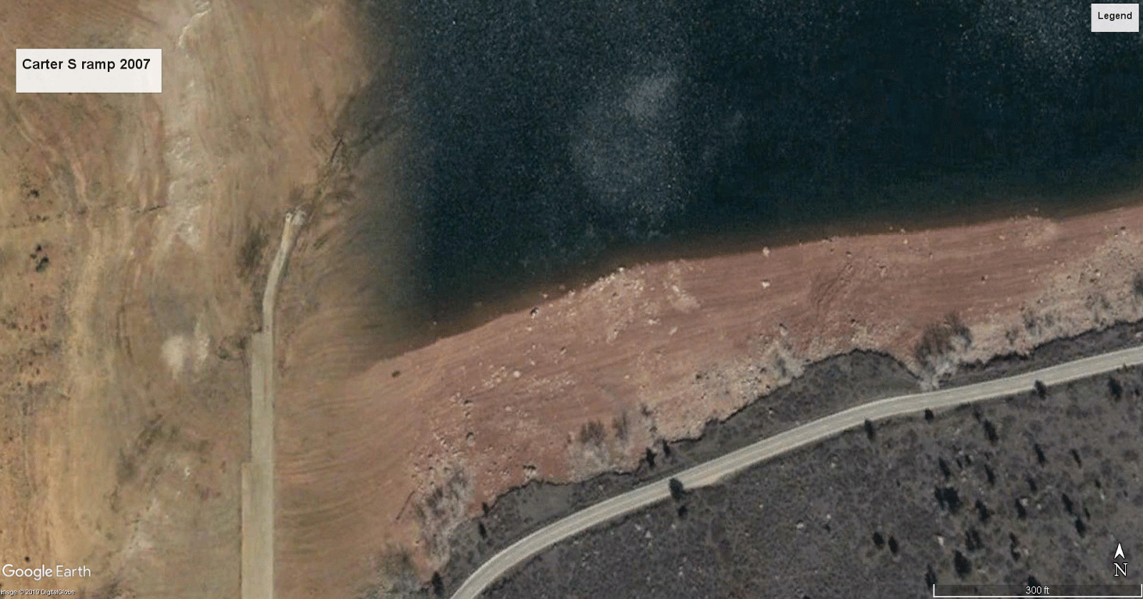 |
Same view of Carter south ramp, April 4, 2007
|
Comments
Post a Comment
Thanks for your comments. They will be reviewed before they can be seen by all visitors.